Scholarships Awarded at Memphis Area Collegiate Geospatial Showcase

Scholarships Awarded at Memphis Area Collegiate Geospatial Showcase

It was our great pleasure to award $2,500 in scholarships and awards at the inaugural Memphis Area Collegiate Geospatial Showcase, which took place last Friday, April 15, at University of Memphis Johnson Hall. Nearly a dozen Memphis area students had submitted presentation abstracts on GIS-related school projects to compete for the awards, and four finalists gave 15-minute presentations at the Showcase event. The first place finishers in each category (undergrad and graduate) won $1,000, and the runners-up each won $250.

First Place:

  • Parth Sinojia (Undergraduate, Rhodes College) - Equitable Access Mapping: Bridging Resource Gaps in Memphis Through GIS Analysis

  • Heather Clendenin (Graduate, University of Memphis) - Assessing landscape factors in the Lower Mississippi Alluvial Valley affecting geneflow of Ursus americanus

Runners-Up:

  • Jacob Ackerman (Undergraduate, Rhodes College) - Finding Breaches: Gaps in Data and the Memphis Aquifer

  • Leta Rowan (Graduate, University of Memphis) - Green Infrastructure and Urban Heat Islands: A Nature-Based Solution for Memphis

The event also featured a panel discussion focused on GIS skills and careers. A panel of GIS professionals from both the public and private sectors fielded questions and shared their advice and experiences with the student audience.

Panelists:

  • Arnisa Davis, PMP, GISP - Manager of Enterprise Resource Planning, Memphis Light, Gas, & Water (MLGW)

  • Megan Farrell - Planner, Memphis and Shelby County Division of Planning and Development

  • Terek Gatewood - GIS Analyst/Assistant Project Manager, Allworld Project Management

  • JT Malasri, PE - Founder and Principal EngineerFounder and Principal Engineer, Malasri Engineering, PLLC

  • Dr. Kate Shields - Assistant Professor of Environmental Studies and Sciences, Rhodes College

  • Scott Trapolino, GISP - Project Manager, Canopy Spatial

We are grateful to our panelists for generously donating their time, and to University of Memphis for hosting the event. We look forward to the Memphis Area Collegiate Geospatial Showcase becoming an annual event as we fulfill our mission of promoting the profession and education of GIS in the Memphis Area.

Photo Gallery

Rhodes College News Release

Memphis Area Collegiate Geospatial Showcase

Memphis Area Collegiate Geospatial Showcase

We are pleased to welcome all geospatially-inclined students and faculty in the greater Memphis area to participate in the inaugural Memphis Area Collegiate Geospatial Showcase!

When: Friday, April 12 from 2:30 - 5:00 PM
Where: University of Memphis - Johnson Hall

This showcase event offers an opportunity for college undergraduate and graduate students to demonstrate their GIS proficiency to an audience of GIS professionals in order to earn financial assistance towards their education and/or research, thanks to our generous members and sponsors. In this year’s event, MAGIC will grant $2,000 in scholarships and/or awards (depending on the student’s eligibility) in a competition open to both undergraduate and graduate students. Students from any college or university in the greater Memphis area will be welcome to participate, and participants will give a 15-minute presentation on a GIS-related project they’re working on. 


MAGIC in 2024

We are delighted to announce the election of our officers for 2024 as well as the election of four new members and two student ambassadors to the board. 

MAGIC officers for this year will be:

  • President: Lee Owens

  • Vice President/President-Elect: David Branson

  • Secretary: Mary Dubose

  • Treasurer: Shawn Anderson


Newly elected to the MAGIC Board of Directors for a three-year term are: 

  • Carrie Baker

  • Haley Feather

  • Jessica Wallace

  • Lesley Rakestraw


Rounding out the MAGIC Board of Directors will be veteran board members: 

  • Lauren Patterson

  • Rob Winkler

  • Scott Trapolino

  • Uday Bhanu Burrey


Finally, we've added two Student Ambassadors to the board:

  • Alyssa Huffman (University of Memphis)

  • Andrew Humphreys (Delta State University)


Best wishes to everyone for the year ahead!

- The MAGIC Board of Directors

22nd Annual MAGIC Conference - November 16 and 17

Go ahead and mark your calendars for the 22nd Annual MAGIC Conference on November 16 and 17, 2023. We will be back at the Reign Event Venue where we had our 2022 Conference a few months ago, and registration will be available shortly. We are currently in the process of planning our workshops, webinars, and trainings for the year, so we will have more announcements about those in the near future. 

MAGIC in 2023

The MAGIC Board of Directors is gearing up for another great year of GIS professional development and training in the Memphis area. In January, we elected our officers for 2023 and also elected three new members to the board. 


MAGIC officers for this year will be:

  • President: Michelle Field, GISP

  • Vice President/President-Elect: Lee Owens

  • Secretary: Robert Winkler

  • Treasurer: Lauren Patterson

Newly elected to the MAGIC Board of Directors are: 

  • David Branson

  • Mary Dubose

  • Uday Bhanu Burrey

Rounding out the MAGIC Board of Directors will be veteran board members: 

  • AJ Robinson

  • Andrew McColgan

  • Scott Trapolino

  • Shawn Anderson.

Best wishes to y'all for the year ahead!

- The MAGIC Board of Directors

Map Gallery deadline extended

The 21st Annual MAGIC Geospatial Conference is just around the corner, and we are looking for a few good maps.

If you have a good map idea in mind, we’d love for you to enter it into our Map Gallery competition! We know you’ve been busy, so we’re extending the deadline to Wednesday, November 9 - a week before the Conference.

The competition is open to all, with separate categories for students and professionals. We will display all map entries on easels at the Conference, and attendees will vote for their favorites. The top finisher in each category will win a cash prize of $150.

“Maps are like campfires – everyone gathers around them, because they allow people to understand complex issues at a glance, and find agreement about how to help the land.”

—Sonoma Ecology Center, GIS/IS Program Web Site

Let’s build a Map Gallery!

MAGIC Conference Agenda Announced!

Please save your edits and have a look at what’s coming to the 21st Annual MAGIC Geospatial Conference! We are excited and honored to announce a tremendous lineup of speakers and presentations for y’all this year. Here are just a few highlights:

  • Disaster response (Esri)

  • Augmented Reality solutions (Bad Elf)

  • Advances in aerial imagery (Nearmap)

  • Cartography tips & tricks (Esri)

  • Mobile information management (MLGW)

  • GIS Integration (Allworld)

  • UAS/Drone Applications (University of Memphis)

  • Streamlining GIS workflows (True North)

  • Search & Rescue mapping (DeSoto County Emergency Services)

  • GISP Certification (GISCI)

All this is in addition to the Scholarship and Map Gallery Competitions, "Where In the Midsouth?" contest, door prizes, lunch, professional networking, and camaraderie that are staples of the MAGIC Conference.

MAGIC Geospatial Conference on November 17 and 18, 2022

Please join us for our 21st Annual MAGIC Geospatial Conference on Thursday and Friday, November 17 and 18, 2022. We are pleased to announce John Nelson of ESRI as the keynote speaker for this year's conference. John works with ESRI's ArcGIS Living Atlas team as a mapmaker and software designer. He also writes educational blog posts and creates instructional videos about anything map-making. He is a highly informative and engaging speaker, and we are excited to hear his take on all things GIS. The conference will feature 2 days of speakers and workshops along with our usual contests, prizes, and scholarship competition. A $35 early bird registration is now open until August 15. For students, registration is $15. All conference registrations include a one-year MAGIC membership.

Trapolino recognized with monthly Mayor’s Award

January 4, 2022

Olive Branch Mayor Ken Adams has recognized City GIS Manager Scott Trapolino as the December Mayor’s Award recipient. Trapolino was chosen among eight city employees that were nominated. Donations fund the $200 award given each month’s recipient so it does not come out of city coffers.  

The presentation was made during the Board of Aldermen meeting on Tuesday evening.

Director of Planning and Development Jason Gambone said of Trapolino, “To help City Engineer (Andy) Swims make a determination as to what upgrades may be warranted to the City’s sewer system to accommodate the Cascades project and others that feed into a particular sewer interceptor line, Scott used GIS to map the entire sewer basin. This built on the work his consulting firm had done over the summer to scan “as-built” drawings into the database and many hours of work Scott has done since to update and make corrections to the City’s sewer infrastructure map.”

Gambone went on to state the final product maps the sewer basin in question and shows every line and property that is currently adding sewage to the interceptor line in question.

“What is most impressive is the quality of the final product and the speed at which Scott was able to produce it,” Gambone wrote. “He literally watched an instructional video on how to prepare a sewer basin map and had it completed within three working days of the request. He is the epitome of a highly skilled and motivated employee; a true problem solver.”  

Swims added, “Our ability to give consultants this kind of information reduces cost and saves time that would otherwise be spent on tracking down this information. After our meeting on this, we handed the consultant the tools they need to come back with designs and recommendations that have a great deal of accuracy. For engineering, this is invaluable.”

Desoto County News

MAGIC Conference Update - COVID protocols

In light of the ongoing surge in COVID-19 cases, we wanted to give you an update on our evolving plans for the 20th Annual MAGIC Geospatial Conference on November 18-19.

  • We are still planning to have the conference in-person at the Memphis Botanic Garden. However, for those who do not feel comfortable attending in-person, we are working on providing a virtual option. Speakers and sessions will be video-recorded and posted online for on-demand playback. The videos will be available only to those who have registered for the conference or purchased a MAGIC membership in the 2021 calendar year. Virtual attendees may still submit entries for the map gallery and scholarship competitions.

  • Anyone wishing to attend in-person must be free of COVID symptoms on the day(s) of attendance. Masks or face coverings must be worn to enter the conference. Our goal is to keep everyone safe!

  • We will provide beverages, continental breakfast, and lunch for in-person attendees, as we've done in years past. We will take extra safety precautions with the food and beverage service (e.g., individually wrapped items, boxed lunches, etc).

  • We will send out a survey to all paid/registered members at the beginning of November to determine how many of y'all will be attending in-person, so we can make sure we have the right amount of food and drinks. Also please note that on November 2, the conference registration fee will increase from $75 to $120.

  • We will offer a full refund (minus Eventbrite processing fees) through November 9 to anyone who's registered for the conference and decides that they cannot or do not wish to attend either in-person or virtually. If you're still considering whether or not to register for the conference out of concern that you won't be able to attend, you can rest assured.

If you’re ready to register for the conference, click here. We are looking forward to seeing y'all and sharing the latest in GIS and geospatial solutions!

Judging now open for Map Gallery Contest | Presentation & Award Ceremony details announced

Judging now open for Map Gallery Contest | Presentation & Award Ceremony details announced

Now that the submission deadline has passed for the Map Gallery Competition, we’ve posted all of the Map Gallery entries at https://www.midsouthgis.org/gallery for your viewing pleasure. Just like at our annual conferences, you have the opportunity to help pick the winners of our Map Gallery Competition. Online voting is now available below, and everyone can vote one time. You do not need to have a current paid membership to MAGIC to vote. Voting will end this Friday at noon.

Also, details have bee posted for the Presentation and Awards Ceremony this Friday, April 23, 2021, at 12:00 PM CDT, We will be viewing presentations from our scholarship finalists and then awarding scholarships and cash prizes to 1st, 2nd, and 3rd place winners in each contest. This lunchtime event will be the GIS version of a game show! Pop some corn and tune in to be inspired and to support our contestants.

Deadline extended for MAGIC Scholarship Competition

The MAGIC Scholarship Committee has announced a one-week extension to the deadline for applications to compete in the MAGIC Scholarship Competition. Applications are now due by Sunday, April 18, and finalists will be notified by April 20, 2021. Finalists must give a 10-minute virtual presentation outlining their project/work via Zoom on Friday, April 23, 2021, and winners will be announced on the same day.

2021 MAGIC Competition Event Announced

We are pleased to announce our Spring 2021 MAGIC Competition event. This will consist of two separate competitions - a scholarship competition for undergraduate students, and a map gallery contest that is open to all. These events are usually a fun part of our annual conference - which we unfortunately had to cancel last November due to the pandemic. These contests will culminate on Friday, April 23, 2021 (Presentation Day), when finalists will give their presentations, judges will pick the winners, and cash prizes and scholarships will be awarded - all on Zoom, where all of you can participate and enjoy the show safely from your home or office.

2020 MAGIC Conference Cancelled

Unfortunately due to the ongoing pandemic and restrictions on large gatherings, the 2020 MAGIC Conference has been cancelled. To continue our educational mission, we will be offering a series of virtual GIS professional development events as well as virtual scholarship competition. We look forward to seeing you in person at the November 2021 MAGIC Conference!

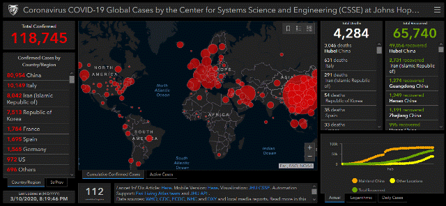
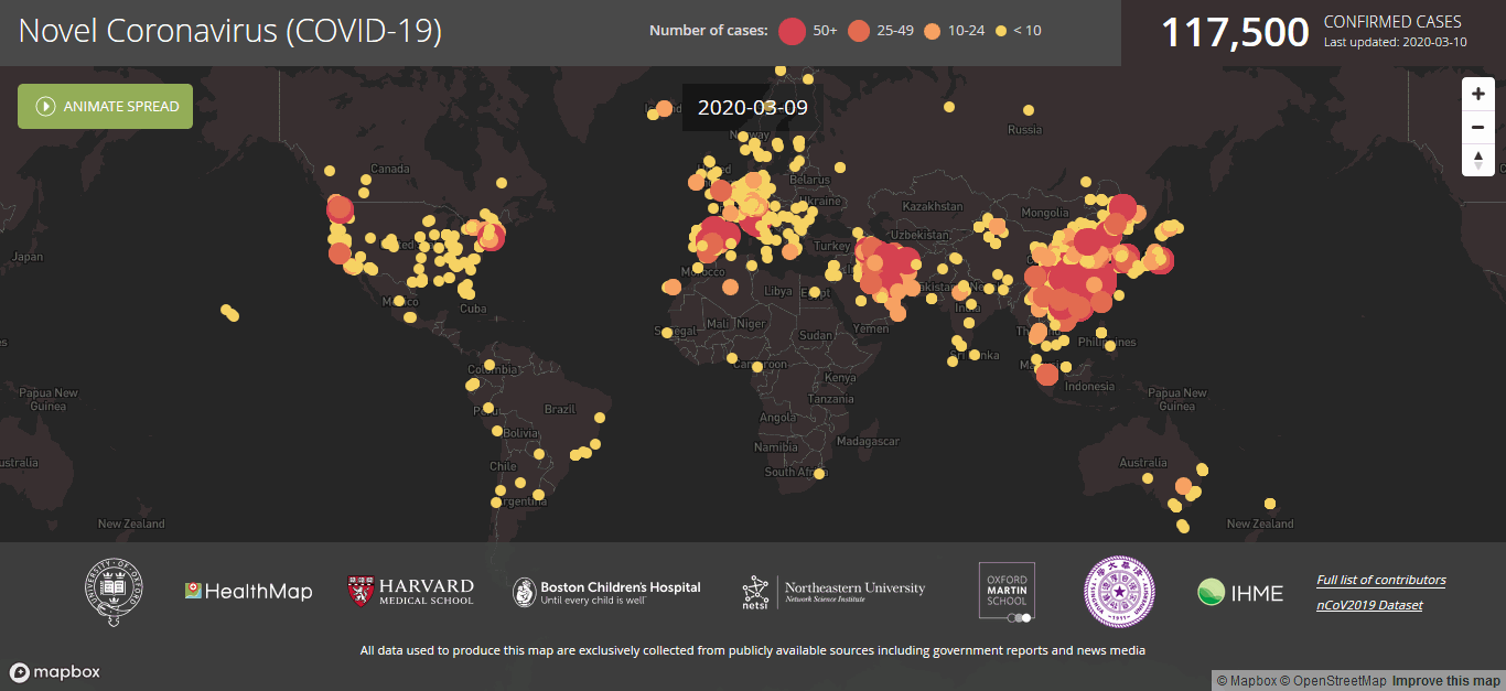
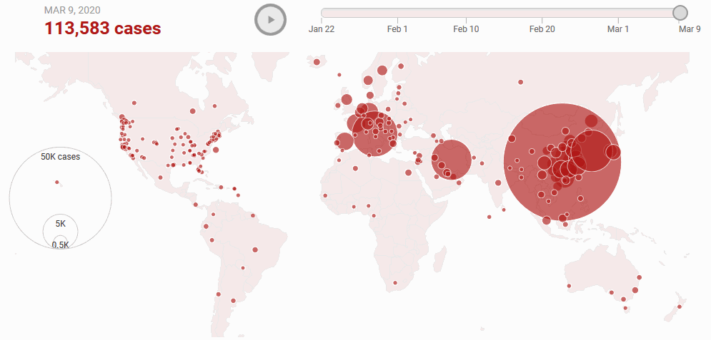
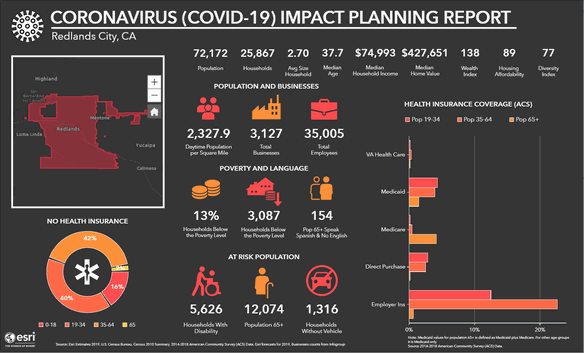
Are you tracking the Corona Virus yet?

If not, it’s about time that you do. Here’s a good list of sites and dashboards to let you see up to date information about the spread of COVID-19:

Do you know of other good resources? Let us know in the comments!!

Memphis Civic Data Hackathon

Do you have ideas for improving the city? Is there a particular issue you’d like to learn about or fix? The Memphis Civic Data Hackathon is an event for everyone ready to get creative and brainstorm solutions to Memphis’s toughest challenges… using data!

Come use your GIS skills and represent MAGIC at this event!! Sign up now…starts tomorrow!

https://memphisdatahack.com/

GIS is revolutionizing the sewer and wastewater industries

GIS Applications that are Revolutionizing the Sewer and Wastewater Industries


“Wastewater” and “sewer” may not be the most glamorous terms associated with water quality management, but an increase in the use of Geographic Information Systems (GIS) has helped to eliminate much of the “dirtiness” surrounding jobs in these industries. Here, I would like to share several GIS applications that are helping sewer and wastewater managers and engineers to steer clear of the mud, so to speak.


Drones. Technically named “Unmanned Airborne Vehicles” or UAVs, these remote sensing apparatuses are not just for kids’ play anymore. Drones may provide engineers with comprehensive information from site inspections of isolated facilities (and those nearby), along with highly detailed 3-D mapping, which provides data that is incorporated into the GIS. This allows wastewater managers to see if and where leaks are occurring in the system. Managers can use historical GIS data to prioritize on-going system maintenance, which can help engineers make more cost-effective decisions when dealing with troublesome leaks and when implementing repairs and upgrades.  


Hydraulic Modeling and GIS Integration. Hydraulic modeling consists of a mathematical model used to calculate the hydraulic qualities (flow) of water to and from a sewer system. Once upon a time this was a very costly and time-consuming process, but the integration of GIS has allowed wastewater utilities to keep up with system attributes such as pipelines, valves and storage tanks. GIS databases can be used for recording pipeline installation dates and for verifying diameter, along with identifying future changes to system workflows in the network, which could be caused by the addition of a neighborhood to the network, for instance. This information is then plugged into the hydraulic model to give engineers a comprehensive view of how changes in the network can affect the amount of flow (hydraulics) from a wastewater plant and throughout a sewer system. 


Infrastructure Mapping via GIS Technology. GIS can be used to identify type, age and condition of sewer and wastewater infrastructure and can provide a graphic interface of the qualities to managers and engineers. These applications can be used to track repairs and upgrades, along with the installation of new infrastructure, and this information can be recorded and stored in a GIS database for easy retrieval at the touch of a button.


This is by no means an exhaustive list of GIS applications that are seeing more use in the water quality realm. As a new decade kicks into gear, GIS applications may very possibly become the norm for wastewater and sewer utilities. Combining speed, accuracy and cost-effectiveness, GIS applications can definitely increase the efficacy of sewer and wastewater networks and simplify their management.


Sources:

7 Ways GIS is Transforming Civil Engineering” by Dmitriy Malets. Retrieved from:

https://technorely.com/blog/gis-in-civil-engineering/


1000 GIS Applications & Uses - How GIS is Changing the World”, a GIS Geography feature. Retrieved from:

https://gisgeography.com/gis-applications-uses/


Geographic Information Systems in Water Management” by John N. Hatzopolous. Retrieved from:

http://www2.env.aegean.gr/labs/Remote_sensing/publications/Jnh_Eydap_02.pdf


GIS (Geographic Information Systems)”, a National Geographic encyclopedic entry. Retrieved from:

https://www.nationalgeographic.org/encyclopedia/geographic-information-system-gis/


GIS and Hydraulic Modeling” by Howard Crothers. Retrieved from:

https://www.esri.com/arcgis-blog/products/arcgis-desktop/water/gis-hydraulic-modeling/


GIS For Water Utilities: Efficiently Mapping Water And Sanitary Infrastructure”, a GIS report. Retrieved from:

https://www.giscloud.com/blog/gis-for-utilities-managing-water-infrastructure/


Use of GIS Growing in the Municipal Water, Wastewater Business” by Paul Ginther. Retrieved from:

https://www.waterworld.com/home/article/16197217/use-of-gis-growing-in-the-municipal-water-wastewater-business


Kristen Persons